Sagar Verma
  • about
  • blog
  • publications
  • repositories
  • remote-sensing
  • •

  • aerial-imagery
  • •

  • computer-vision
  • •

  • deep-learning
  • •

  • datasets
  • •

  • research
  • •

  • experiments
  • Benchmarking Vision-Language Models for Property Intelligence

    A systematic evaluation of vision-language models on automated property analysis tasks from drone and aerial imagery.

    7 min read   ·   March 21, 2024

    2024   ·   computer-vision   deep-learning   ·   research

  • 3D Scene Understanding with GeoLLMs

    Exploring approaches to build 3D-aware language models for geospatial scene understanding from multi-view imagery and 3D data.

    9 min read   ·   January 18, 2024

    2024   ·   computer-vision   deep-learning   ·   research

  • Building a Satellite Image-Text Foundation Model with GeoCLIP

    Adapting OpenCLIP for satellite imagery using large-scale datasets like LAION-400M and SatlasPretrain.

    9 min read   ·   September 19, 2023

    2023   ·   remote-sensing   deep-learning   datasets   ·   research

  • Property Intelligence from Satellite and Drone Imagery

    Automated property analysis using segmentation models on satellite and drone imagery at varying resolutions.

    7 min read   ·   August 22, 2023

    2023   ·   computer-vision   remote-sensing   deep-learning   ·   research

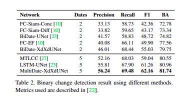
  • Benchmarking Change Detection: Lessons from QFabric

    Experimental results from benchmarking change detection, change type classification, and status tracking on the QFabric dataset.

    5 min read   ·   August 21, 2023

    2023   ·   remote-sensing   deep-learning   ·   experiments

    image
  • <
  • 1
  • 2
  • 3
  • 4
  • >
© Copyright 2026 Sagar Verma.